
By Scott Martin
This is probably one of the most difficult forecasts that I have had to make since we've started Racecast Weather as we have Tropical Storm Eta that has no idea at all at exactly where it wants to go. This forecast can and will change if there are any drastic changes to the forecast track of Eta. At this point, I'll give you three scenarios as the forecast confidence is very low...
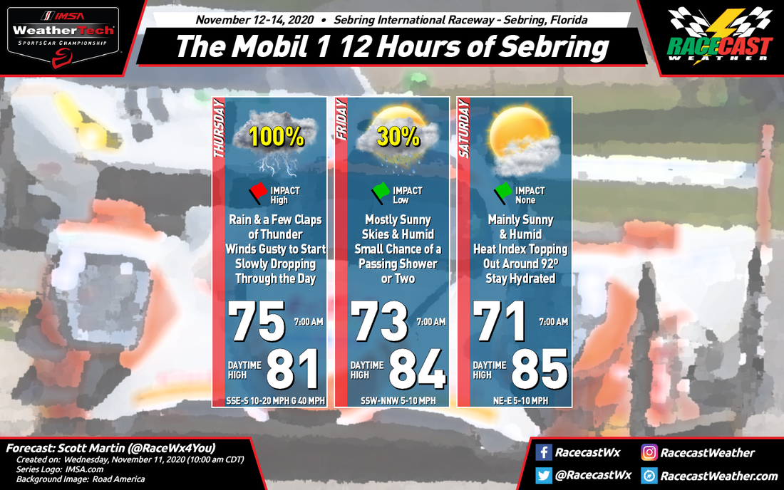
THURSDAY: The GFS Model shows the center of Eta close enough to the west coast of Florida to keep cloudy, breezy, and rainy conditions over Sebring throughout the entire day. The European Model is much of the same story but is showing rain intensity may be less at times. NWS Tampa Bay (the official forecast office for the Sebring area) has a 50% chance of showers occurring mainly after 1:00 pm with winds gusting to 20 MPH at times. As of now, we'll say showers will be possible throughout the day with breezy conditions as winds will be out of the south to southeast at 10-15 MPH with gusts around 20 MPH. The morning low at sunrise will be around 74 degrees with the afternoon high reaching around 84 degrees. We'll go with 50% chance of rain for now.
FRIDAY: The GFS shows the center of Eta drifting farther out west over the Gulf of Mexico which will bring a much drier day to the area with a good bit of sunshine. The European has a little more rapid movement to the west with Eta and almost agrees with the GFS. The NWS has in their forecast mostly sunny skies with a very small chance of a passing shower. All three of these are in close agreement so we'll go with mostly sunny skies with only a 20% chance of a passing shower during the day. The morning low will be around 73 degrees and it will warm to around 86 degrees for the afternoon high. Winds will be calmer out of the south at 5-10 MPH.
SATURDAY: Eta will get caught up and absorbed into an approaching cold front that will be moving through Mississippi and Alabama during the late hours on Saturday, according to the GFS. This will keep Sebring dry throughout the day with this scenario. The European is relatively the same with the GFS and it keeps Sebring dry throughout the day. The NWS has it being sunny and very warm. We'll go with mainly sunny skies and warm with the afternoon high topping out around 86 degrees after starting off around 70 degrees at daybreak.
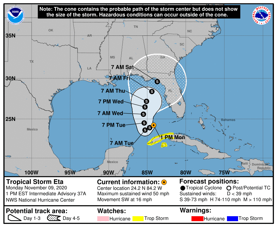
NATIONAL HURRICANE CENTER: Unfortunately, as I was typing out this forecast, the National Hurricane Center has their official forecast track of Eta hugging the west coast of Florida as is will be moving slowly north-northeastward through the week and into the weekend. If this scenario plays out, rain chances will have to be increased for each day.
If you notice how wide the cone of uncertainty is for Saturday, that will tell you how low the confidence the forecast is. It shows that the center could potentially make a landfall from as far away as Pensacola, Florida, to as far east as Bradenton and just north of Sarasota, Florida.
This will be an ever-changing forecast so I'll have updates throughout the week. Stay tuned.


