
By Doug Schneider
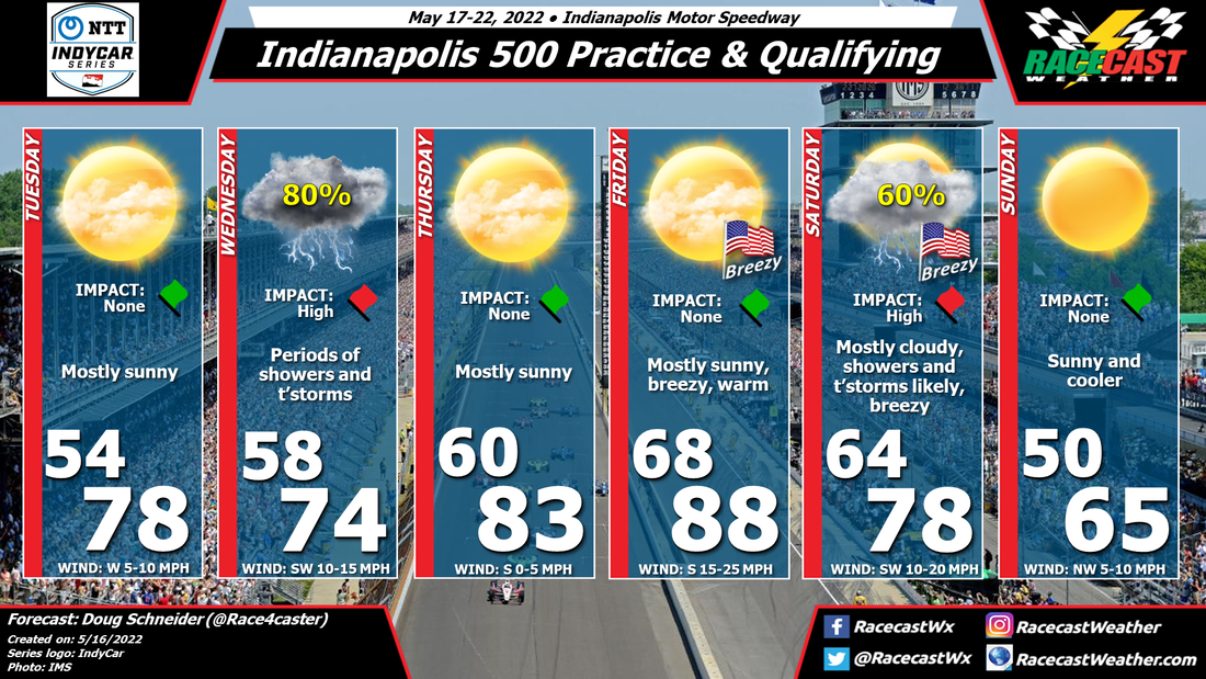
The forecast for Indy 500 practice week and qualifying next weekend is coming into better focus today. The two days that are most likely to be impacted by weather are Wednesday and Saturday. I think all other days will have dry conditions, although there is some uncertainty about Thursday.
Opening day of practice on Tuesday should have good weather. There will be some high clouds around, creating some milky sunshine, but overall, mostly sunny is the best way to describe it. A chance of rain will arrive in the area on Tuesday night, with the bulk of the rain associated with a low pressure system will be arriving on Wednesday morning. I expect two main waves of showers and thunderstorms on Wednesday - one in the morning, and the other in the late afternoon and evening. There could be a good amount of rain too, around a half inch total, which will make track drying difficult between these two rounds, and not much sunshine to help the process. Overall, I doubt there will be much on-track activity on Wednesday.
High pressure builds over the area on Thursday, but there is some concern that afternoon showers and thunderstorms will pop up as instability increases. One model, the GFS, is pretty excited about this happening late in the day, but I am going to lean the forecast in a drier direction, which is what the NAM, ECMWF, and NBM show. These models keep the chance of rain south of central Indiana.
The main impact on Fast Friday will be winds, which will be from the south at 15 to 25 mph, with some gusts over 30 mph possible at times. This could make for difficult conditions as teams prepare their qualifying set ups. Temperatures will be warmer due to the strong south wind, reaching the upper 80s.
A cold front is expected to cross the area on Saturday. The exact timing of the frontal passage and the best chance of rain is still uncertain this far out, but I think that the qualifying sessions are likely to be impacted at some point. Sunday will be dry behind the front, and quite a bit cooler with highs in the mid 60s. This should be good conditions for some very fast speeds on Pole Day.


