By Doug Schneider
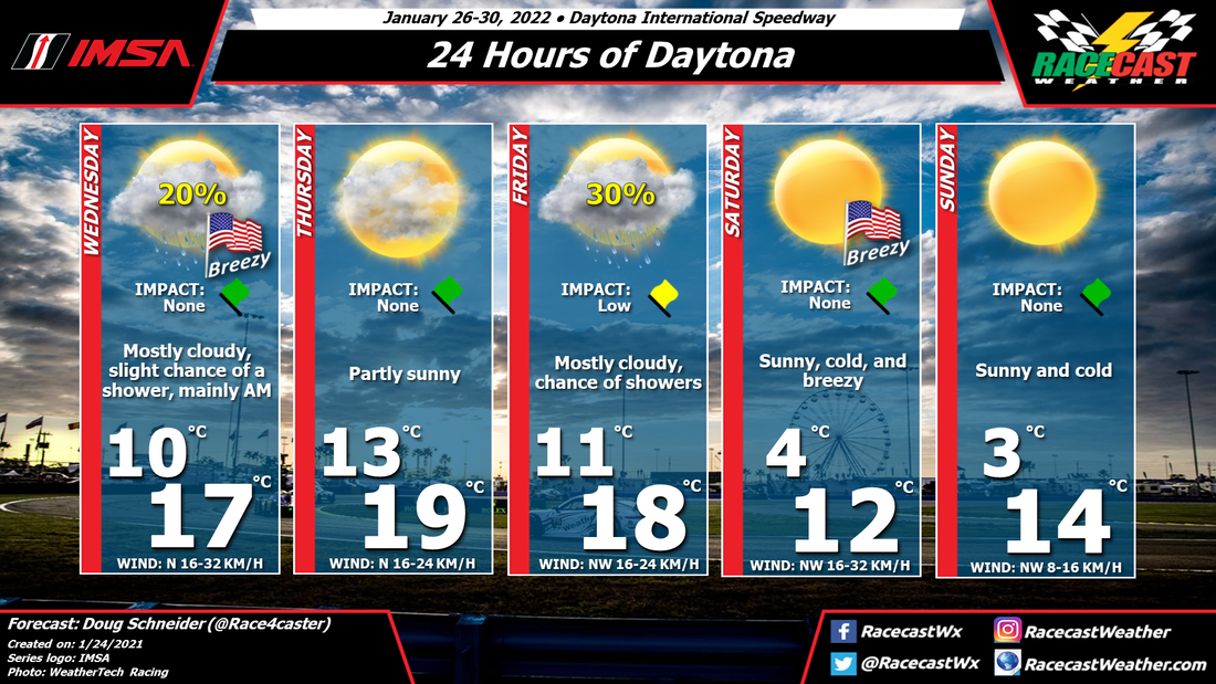
The main weather impact on the 24 Hours of Daytona events will be the temperatures. Daytime temperatures are going to stay below normal throughout the entire event (normal high is 69), especially on Saturday and Sunday, and a breeze will make it feel even colder. The good news is that the 24 hour race appears to be rain-free.
A low pressure system will be tracking across northern Florida on Tuesday, bringing a good amount of rain through Tuesday night. The current timing of this system suggests that some light rain could continue into Wednesday morning. Since the practice sessions that day are only in the afternoon, I do not expect any impacts.
An area of high pressure will move across the Southeast states on Thursday, which should provide a dry and partly sunny day. I will mention that some models keep a low pressure trough off the east coast of Florida, and spread a few showers inland. For now, I think the chance of that is too low to mention in the forecast, so I'm keeping it dry. Thursday will have the warmest temperatures of the event, in the mid to upper 60s.
A deep upper level trough digs southward into the Southeast states on Friday, which causes a low pressure area to form off the east coast of Florida. This will result in the chance of some showers around on Friday and Friday night. A cold front will also accompany this trough passage, and bring much colder air for Saturday and Sunday. It will be breezy behind the front, with a northwest wind at 10 to 20 mph, gusting up to 30 mph. Dress warmly for the overnight hours, as lows will be in the 30s.