
By: Stephen McCoy - @stephenmmcc
A mix of weather conditions look to be in store for the Verizon Indycar Series as it heads to Gateway Motorsports Park to race under the lights at the Bommarito Automotive Group 500. The impact for this weekend essentially starts today as a strong surface low pressure system is moving eastward through the region, causing severe weather in southeastern Missouri and southern Illinois. As the system continues to move across the country, a surface high pressure system will begin to build in over the area. On Thursday, the system will reach its maximum extent, covering much of the Midwest, Southeast, and Mid-Atlantic states. Also on Thursday, an upper level shortwave trough is expected to develop over the Rocky Mountains, tracking eastward with an accompanying low pressure system at the surface that will develop slightly east of the trough.
As the surface high pressure system centers over the Midwest, cooler air will wrap anticyclonically (clockwise) around the system, bringing drier air from the north to many of the states in the aforementioned regions. Over eastern Missouri, winds will be from the south to southeast as the center of the system will be to the east of the region. To the west, the surface low pressure system will bring warm air from the southwest and a warm front is expected to develop where the air from the two systems meet.
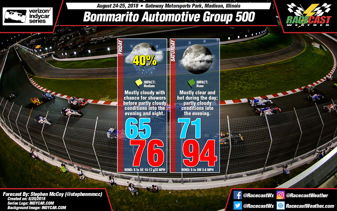
On Friday, the warm front will move through Missouri as the surface low pressure system continues to track eastward. Ahead of the front, surface winds will be out of the south to southeast as they get forced away from the area. As the front approaches the St. Louis region, mostly cloudy to overcast conditions will be likely along with a chance for showers. The models indicate that precipitation will most likely begin in the early to mid afternoon and continue into the late afternoon or early evening, with the GFS showing precipitation ending later than the ECMWF. Timing of the frontal passage will largely determine the high temperature for the day: if the front passes early, temperatures will be higher as there will be more time for daytime heating to occur but temperatures will be cooler if the front passes later in the day. Regardless of timing of the front, precipitation will have a possible impact to on-track sessions for Friday. Partly cloudy to mostly clear conditions will be likely after the frontal passage as air in the lower levels will be drier behind the front.
On Saturday, upper levels winds are expected to shift towards the west or northwest, bringing drier air and clear conditions to the upper portions of the atmosphere. Winds in the lower levels will be from the southwest and will also bring drier air to the region for much of the day, though moisture will increase towards the evening, resulting in partly cloudy conditions for the Indycar race Saturday night. At the surface, the high pressure system from Thursday is expected to strengthen and elongate as it move eastward into the Atlantic Ocean. As it does, winds for the region will be out of the south to southwest, bringing moisture from the Gulf Coast. The result will be air temperatures in the low 90's with dew point temperatures in the low 70's; heat index values will likely break 100 degrees with these conditions. The heat will be prevalent for the Pro Mazda Championship race and Indy Lights race, but with the Indycar race starting after the heat of the day, temperatures will be closer to the mid 80's and cooling as the evening progresses.
As the surface high pressure system centers over the Midwest, cooler air will wrap anticyclonically (clockwise) around the system, bringing drier air from the north to many of the states in the aforementioned regions. Over eastern Missouri, winds will be from the south to southeast as the center of the system will be to the east of the region. To the west, the surface low pressure system will bring warm air from the southwest and a warm front is expected to develop where the air from the two systems meet.
On Friday, the warm front will move through Missouri as the surface low pressure system continues to track eastward. Ahead of the front, surface winds will be out of the south to southeast as they get forced away from the area. As the front approaches the St. Louis region, mostly cloudy to overcast conditions will be likely along with a chance for showers. The models indicate that precipitation will most likely begin in the early to mid afternoon and continue into the late afternoon or early evening, with the GFS showing precipitation ending later than the ECMWF. Timing of the frontal passage will largely determine the high temperature for the day: if the front passes early, temperatures will be higher as there will be more time for daytime heating to occur but temperatures will be cooler if the front passes later in the day. Regardless of timing of the front, precipitation will have a possible impact to on-track sessions for Friday. Partly cloudy to mostly clear conditions will be likely after the frontal passage as air in the lower levels will be drier behind the front.
On Saturday, upper levels winds are expected to shift towards the west or northwest, bringing drier air and clear conditions to the upper portions of the atmosphere. Winds in the lower levels will be from the southwest and will also bring drier air to the region for much of the day, though moisture will increase towards the evening, resulting in partly cloudy conditions for the Indycar race Saturday night. At the surface, the high pressure system from Thursday is expected to strengthen and elongate as it move eastward into the Atlantic Ocean. As it does, winds for the region will be out of the south to southwest, bringing moisture from the Gulf Coast. The result will be air temperatures in the low 90's with dew point temperatures in the low 70's; heat index values will likely break 100 degrees with these conditions. The heat will be prevalent for the Pro Mazda Championship race and Indy Lights race, but with the Indycar race starting after the heat of the day, temperatures will be closer to the mid 80's and cooling as the evening progresses.


