
By: Stephen McCoy - @stephenmmcc
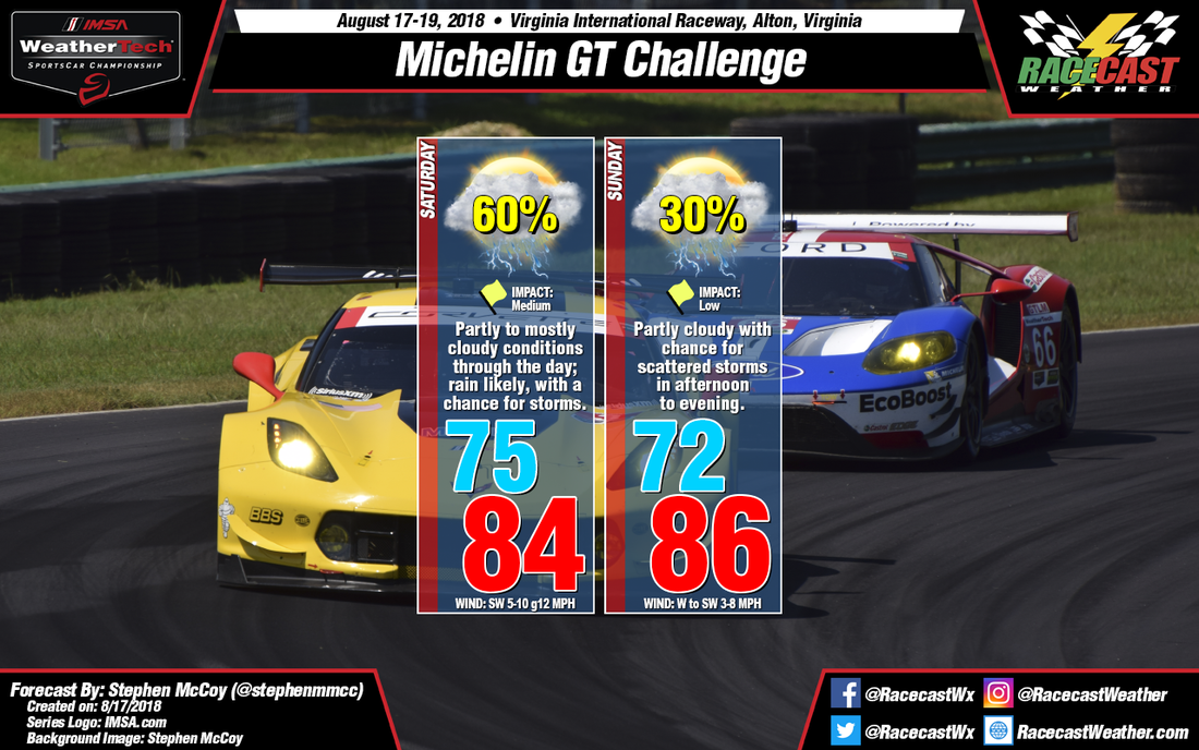
Grab an umbrella and a raincoat if you're planning on attending Saturday's or Sunday's sessions of the Michelin GT Challenge at VIRginia International Raceway. Precipitation will be likely on Saturday with a chance for scattered thunderstorms in the afternoon and evening; Sunday also has a chance for scattered thunderstorms in the afternoon and evening.
In the upper levels, a shortwave trough mentioned in the previous forecasts will move eastward towards the Atlantic Ocean with its center positioned over the Midwest. As a result, winds in the upper levels will be from the southwest, bringing moisture to the region from the southeastern states. In addition, winds in the lower levels will be from the west and southwest, advecting moisture to the lower levels as well. At the surface, a cold front extending from a low pressure system centered over New England will track southward towards central Virginia through Sunday. Due to the large amounts of moisture in the atmosphere, precipitation over the region looks likely on Saturday. Depending on how far southward the cold front extends, a chance of thunderstorms is possible as the front would act as the necessary lifting mechanism to create scattered storms. With the approach of the front, winds at the surface will be from the southwest, with some breezy conditions as the winds at both the surface and low levels are from the same general direction.
The best chance for precipitation will be in the afternoon and will likely affect the end of WeatherTech qualifying and/or the Biscuitville Grand Prix. Rain chances will continue into the evening, but will slowly decrease overnight. With cloud cover and precipitation, temperatures will likely only reach into the mid 80's, with heat index values in the upper 80's to low 90's.
On Sunday, as mentioned in the previous forecast, upper level winds are expected to return to zonal flow as the shortwave trough moves into the Atlantic Ocean. At the surface, the cold front is expected to stall before it reaches southern Virginia, creating a stationary front to the north of the track. As winds on either side of the front converge, the cooler air could undercut the warm air, creating a chance for scattered thunderstorms Sunday afternoon. As the track will be to the south of the front, winds from the west to southwest will advect warm air to the region, raising temperatures towards the upper 80's. Drier air in the upper and mid levels of the atmosphere will lead to partly cloudy conditions through the day.


