
By Scott Martin.
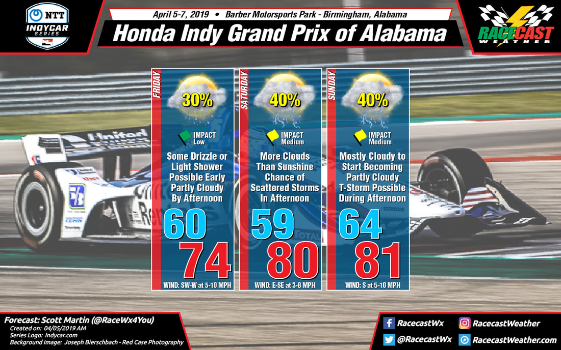
Much of the activity that affected the area late on Thursday moved out earlier and has left us with a few areas of drizzle to very light rain close by. We may have a few light showers or drizzle on the back side of a departing low wrap around and move across the track during the morning hours, but the afternoon and early evening hours look to be dry. We're starting off with mostly cloudy skies but that cloud cover will dissipate somewhat and leave us with a mix of sun and clouds late in the day. Temperatures will start off in the lower 60s and climb up into the mid-70s for the afternoon high. Winds will be out of the southwest to west at 5-10 MPH. Chance of rain will be around 30% during the morning but will be dropping during the afternoon hours. If any more rain falls this morning, amounts will be very light, less than 0.05 inches.
Saturday is trending pretty much the same as yesterday as we'll continue to have a chance of a passing shower or thunderstorm during the main heating of the day, after 1:00 pm. We'll have more clouds than sun with temperatures starting out in the upper 50s and topping out around 80 degrees. Winds will be out of the east to southeast at 3-8 MPH. Rain chances are around 40% and if any showers pass over the track, amounts will be less than 0.10 inches.
Sunday continues to trend dry as the system is expected to move in later in the evening. I'm still going to keep a chance of a passing shower or thunderstorm throughout the afternoon as there will be plenty of instability available, but the main action will not arrive into the area until well after the completion of the Honda Indy Grand Prix of Alabama. If any storm does develop during the afternoon, it will be working in unstable air, so the possibility of a strong storm is not out of the question. Temperatures will start off in the mid-60s and climb into the lower 80s for the afternoon high. Winds will be out of the south at 5-10 MPH. Skies will be mostly cloudy to start but some clearing is expected to occur during the late morning and into the afternoon becoming partly cloudy, and I'm putting the chance of rain at 40% for now.
Radar is up and running, just click on the Radar link at the top of the page. I'm about to head out to the track. I hope you have a great day and a great weekend.


