
By Doug Schneider
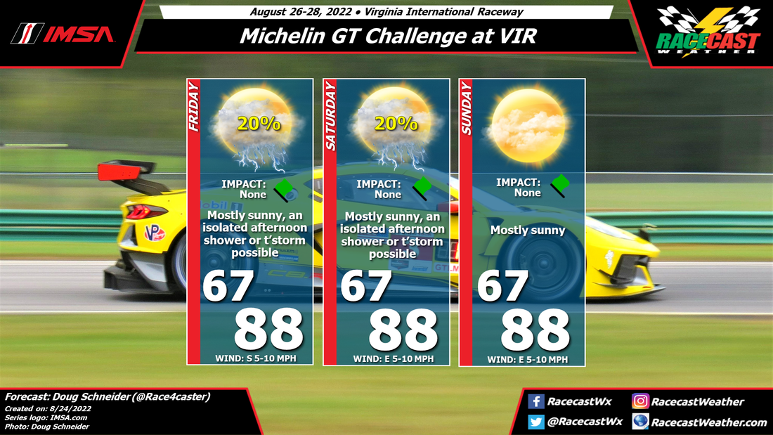
Since my initial forecast I posted on Monday for IMSA weekend at VIR, the chance of rain has trended downward. I'm more confident today that there will be only a small chance of seeing rain Friday and Saturday afternoons. The vast majority of the event will be dry and mostly sunny, good news for those of us who will be in attendance.
A weak cold front will be approaching the Appalachians from the west on Friday, and most of the shower activity on Friday should be near the mountains and foothills. The movement of these showers will be from west to east, so there is a small chance that one could reach VIR late in the day, if it can hold together long enough as it moves east off the mountains.
The weak front will be east of the mountains on Saturday, but it appears to be so weak that there will be very little impact from it on the weather. The shower activity on Saturday afternoon will be across the Piedmont, but it may be mainly to the east of VIR. With the front being positioned somewhere in the Piedmont region, I think a shower or thunderstorm will be possible on Saturday, but it's just a small chance, and most of the day will be dry.
On Sunday, a high pressure ridge over the Atlantic starts to build over the Carolinas, which should suppress afternoon shower development. I've taken out the mention of showers and storms from Sunday's forecast, because I think the chance of one is too low to warrant a mention.
Temperatures will be near normal throughout the weekend, with light winds. I'm looking forward to spending the weekend at my favorite track.


