
By Doug Schneider - @Race4caster
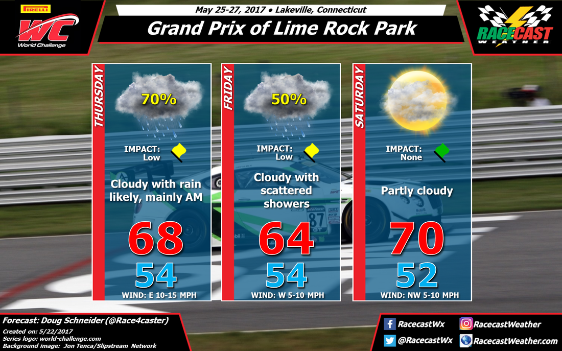
An unsettled weather pattern this week across the northeastern states will bring some rain to Lime Rock Park for Thursday and Friday, but conditions will be improving for race day.
As teams load into the track on Thursday, low pressure over Ohio will pump moist air into New England. This moist air will ride up and over a warm front that will be located near Long Island, and will likely produce a good amount of rain at the track. Thursday definitely looks like the wettest of the three days.
The center of the surface low pressure will track across northeast Connecticut Friday morning, continuing to Boston and off the coast of Maine by the evening. This will take the bulk of the heavier rain east of the track, but there will still be moisture wrapping around the upper level trough and a little instability that will keep a chance of showers in the area. I think the greatest coverage of showers will be on Friday morning, with less coverage through the afternoon. But right now, I'm not entirely confident with how fast this system will move east, so there could be scattered showers around all day. I do not expect that there will be heavy rain that will cause cancellations or major delays like we saw at CTMP - more of a light on/off rain rather than a steady moderate/heavy rain - so I have the impact on Friday as low.
Saturday will be the best day of the event as the low moves away and high pressure builds in. With partly cloudy skies and temperatures around 70 degrees, it looks just about perfect for racing.
In the forecast graphic, I have chosen a picture of Andrew Palmer's car from last year at Lime Rock Park as a reminder that he is still recovering from injuries sustained in a terrible crash at the track last year. Please keep Andrew and his family in your prayers.


