By Doug Schneider 
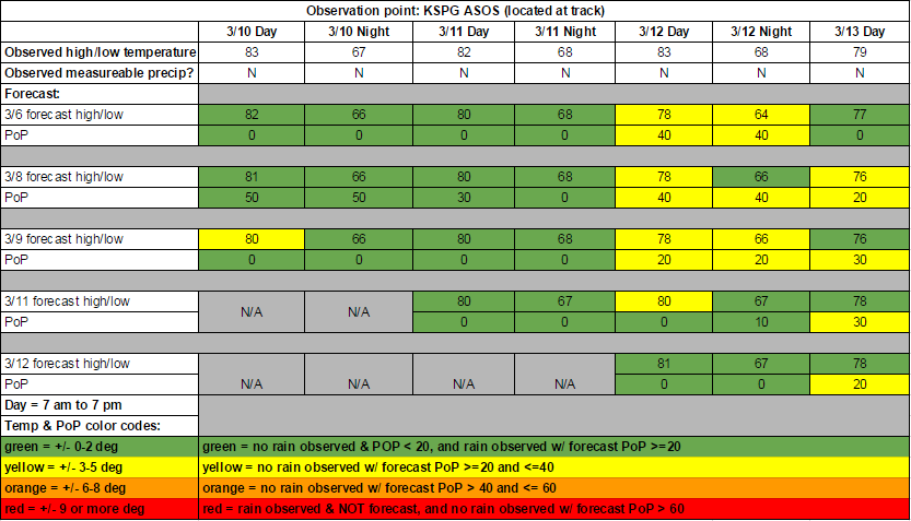
The St. Pete street course is partially located at the Albert Whitted Airport (KSPG), so getting accurate observed data for the track is really convenient. Overall, I think the forecast worked out okay. Thursday and Friday were sunny and dry, and the temperature forecast both days was pretty accurate. There was a good breeze through the event, which was accurately forecast. The big question through the week was whether rain would arrive over the weekend. There was a lot of uncertainty about this, and the timing of the potential rain shifted from Saturday to Sunday. As it turned out, there wasn't any rain at the track until after the racing was over, at 9 pm Sunday night. The downside of the forecast was mentioning a chance of rain on Saturday. I should have leaned the forecast toward the slower model. But at least it was only a 40% chance, and I did trend it downward with later forecast updates. I kept the rain chances low on Sunday, which worked out well. I wasn't impressed with the potential for rain on Sunday, as it looked like the low pressure system would be lifting farther northeast and weakening on the southern end of the front. My Twitter posts on race day were downplaying the potential for rain while others on Twitter were posting radar images and getting excited about a wet race mixing things up. Radar loops showed the rain was moving northeast, and would pass north of St. Petersburg. Given all the uncertainty about the rain and the model disagreement right up to Friday, I'm mostly satisfied with how the forecasts worked out.
By Scott Martin. Well it's time to see how well I did on my forecasts from this past week for the opening weekend of the Pirelli World Challenge at Circuit of the America. I am very pleased with how this forecast turned out. I know what you are saying... "There are a few yellow boxes on your grade sheet," and you would be correct. Looking at the forecast models that I used this past week, I thought that my temperatures were going to be a little conservative. I decided to stay conservative due to a drier airmass over the area and there were lower humidity levels due to the flow not coming from the Gulf of Mexico. I also thought that the added cloud cover would hinder the highs for Sunday. Unfortunately, I underestimated the change in air flow back from the gulf. I did raise my guess back up, but still missed from being in the green by 1 degree. The best news of all of this is that all of my boxes for precipitation are green. I did go with a slight chance of rain for Sunday on a few of my forecasts, but I also stated in those blog entries that I didn't believe any precipitation would fall during the event, and that I was Just being safe in putting in a slight chance. Bottom line: It's still not a perfect forecast, and that is something that I will strive to achieve. Weather is one of the hardest items to predict correctly every time. I missed the high temperature for Sunday by 5 degrees or less on most of my forecasts. The best news of all of this is that no rain fell at the track during the event weekend. Thank you for following and trusting our forecasts for your favorite racing series. We strive to put the best information out there. Doug will have the forecasts for this week's events down in St. Petersburg for the Pirelli World Challenge, the Verizon Indycar Series, Indy Lights, Pro Mazda, and USF2000 series. Have a great week. By Doug Schneider (@Race4caster) Overall, the weather for the Rolex 24 played out as expected. It was pretty clear from my first forecast the Sunday before the race that Wednesday and Thursday were going to be wet, and the models were in surprisingly good agreement on that. A total of 2.93 inches of rain fell at the airport right beside the speedway both days. There were some difference in timing that made it difficult to know exactly when the rain would end. It turned out to last a little longer than expected, ending Thursday evening. A little rain fell after 8 pm Thursday evening, so I have that ugly red box for my zero PoP that night. But the rain forecast was pretty much spot on. The temperature forecasts were reasonably good. On most days I was within 2 or 3 degrees. A review of the Rolex 24 weather in animated gif form: Wet practice and qualifying, but who cares? RACECARS! Lows in the 40s. Florida natives were like: And everyone was sweating out that amazing finish. Wow!
By Scott Martin It has been a while since I have done a forecast verification for an event. Being a full-time college student while being a stay-at-home dad teaching homeschool to three children takes a lot of time away, but I really do enjoy it. I was able to squeeze in a little extra time today to do a verification for the Trans Am series at NOLA Motorsports Park from this past weekend, and here are the results.
As you can see, I was pretty close to being dead-on for most of the forecast. Where I struggled is underestimating the cold air that came with a cold front on late Friday evening. A north wind helped to keep high temperatures lower on Saturday as I forecasted temps to be warmer. It was not a big miss (less than 5 degrees), but did have one forecasted high 6 degrees too warm. I also didn't expect temperatures to warm as much for Friday before the cold front moved through, but was only off by 4 degrees and less. Now there was no doubt that precipitation would stay out of NOLA, and I forecasted a 0% chance throughout the time frame. I did think that there would have been a slight chance of rain with the front passage early on Saturday morning on my first forecast, but changed that to none due to the fact that models were trending dry and moisture was staying well to the north. Most meteorologists would claim this as a very successful forecast, and as a meteorology student, I consider it one as well. I still see that I need to work in some areas. A perfect forecast is nearly impossible, but my goal is to have as many of those slots to be in the green. Our next forecast will be for the Trans Am series action at COTA in November (6-8), and then at Daytona (12-14). After that, our last forecast will be for the 25 Hours of Thunderhill in December. By Doug Schneider The forecast for Petit Le Mans was extremely difficult due to several different factors in the weather pattern that developed through the week and poor model consistency. But I won't make that an excuse. This was not a good forecast for me, and I sincerely apologize. When I began to look at the data over a week before the race, the models were pointing toward a weak trough off the east coast and a large ridge over the central states that would push a front through on Wednesday followed by a dry northwest flow aloft across Georgia Thursday through Saturday. Sunday afternoon, some, but not all, of the models started to change their tune, showing a deeper and slower upper trough. At this point, none of them hinted at the existence of Hurricane Joaquin. Gradually the models came into better agreement on a deep trough over the southeast, with Joaquin being positioned east of the Bahamas. By the Wednesday forecast update, I started to push the chance of rain into Friday, but it was not enough as the models continued to show a slower and slower system that would pick up tropical moisture from Joaquin. There was still quite a bit of disagreement among the models on where the moisture axis would be located. I was too slow to jump on the bandwagon, as I was waiting for better model agreement on where the rainfall would be. It wasn't until Thursday's forecast update that I brought in a chance of rain on race day. In hindsight, this was probably a day too late. At least I saved face a little with good forecasts on Thursday and Friday. Better late than never, I suppose. Here's my forecast week, in GIF form. Saturday: Feeling good, it's going to be a nice and easy forecast to end the season. Sunday: GFS model starts to hint a strong low pressure system developing in the southeast, while other models disagree. Monday: Now other models are starting to agree with the GFS, but I remain skeptical. We'll see. Wednesday: Hurricane Joaquin might come into play. Uh oh. Thursday: Welp. I messed up. Petit Le Mans was pretty much like -
By Doug Schneider COTA and VIR are two really good tracks to verify forecasts because there is an airport with a reliable weather sensor within ten miles of both tracks. So here's a look back at how I did with my forecasts for Lone Star Le Mans and Trans Am at VIR. Lone Star Le Mans was not a difficult forecast as I was confident that most of the event would stay dry, with the exception of Wednesday. Temperatures were clearly the main concern, with highs each day reaching into the lower to mid 90s. There was a shower that grazed the track on Wednesday, and 0.01 inches of rain was recorded at the airport that day, verifying my 20% rain chance. My forecast high temperatures were never off by more than two degrees. Trans Am had a very wet weekend at VIR. I'm pretty sure every session was affected by rain or at least a wet track. My initial forecast called for a chance of rain on Thursday, Friday, and Saturday, but I did not have it lasting into Sunday. My next forecast update corrected that, with rain chances rising to 70% Thursday night through Saturday, then up to 100% on my next update. This was the period when the greatest amount of rain fell. Light rain continued into Sunday, and a light mist or drizzle was over the track for the race start on Sunday afternoon. My forecast temperatures verified pretty well each day and night. What I didn't forecast well (and it doesn't show up in the chart) is rainfall amounts. In my posts, I had mentioned 0.5 to 1.5 inches with my 9/23 forecast, then 1 to 2 inches with my 9/24 forecast. Both of these forecasts were actually on the higher side of what the models were predicting. It turned out that 4.74 inches of rain was recorded through the event at the Danville airport!
By Doug Schneider Let's take a look back at the good, the bad, and the ugly of my race forecasts from the past weekend at Watkins Glen and Road America. The low pressure system that was expected to bring rain to the Watkins Glen area Thursday through Friday never really did much. There were some showers around the Finger Lakes region and across Pennsylvania Thursday afternoon and evening, but they never hit the track or the airport. My initial forecast for Thursday night and Friday had rain chances that were too high, and my temperatures on Friday were off by quite a bit due to less cloud cover than expected. My initial Sunday forecast called for a low pressure system to track across western New York over the weekend. I was confident that there would be rain, but I was uncertain about the timing of the best rain chances. This initial forecast wasn't too far off from what actually happened, but the problem was that I went the wrong direction with the Tuesday update. The models changed their tune and started to show a more southerly track of the low pressure center across northern Virginia and Maryland, keeping the rain south of the area. I bit on this change a little too hard, and took out all the rain chances from Saturday and Saturday night. In hindsight, I probably should have hedged my bets and left in at least a small chance of rain as the large scale pattern was still an active one. Sometimes it is best to focus on the larger pattern shown by the models rather than focus on the smaller details, which can often change drastically from one model run to the next. Sure enough, the Wednesday model runs completely flip-flopped, and went back the their earlier track of the low across upstate New York. My Thursday morning update caught this, and ended up being accurate. I mentioned in my Thursday blog post that the heaviest rain would fall from late Saturday morning through Saturday night, with Sunday's rain being lighter and more on/off showers. My Saturday update expressed doubt that TUDOR qualifying would happen at all due to heavy rain expected around that time, and in fact it was canceled. The observed rainfall on Saturday and Saturday night was 1.86 inches at the airport, with 0.03 inches recorded on Sunday. Based on what I was seeing while watching the race, it looked like the track received more rain than that on Sunday, but as expected, it was definitely more on/off shower activity rather than Saturday's steady rain. The forecast for Pirelli World Challenge at Road America was much better than the Watkins Glen forecast. It was also an easier forecast, as the weather was great for the entire event, with no rain recorded and comfortable temperatures each day.
Rain showers were scattered around eastern Wisconsin on Thursday, but never hit the track or the airport. My temperature forecasts for Friday and Saturday were pretty much spot on. Saturday night ended up with fewer clouds than I had initially suspected, which resulted in cooler temperatures than forecast. A low pressure system dropping southeast out of central Canada brought some rain to Minnesota and western Wisconsin on Sunday. The rain got as far east as Fond du Lac, about 20 miles west of Road America, before it dissipated. I don't feel too bad about having a low to slight chance of rain mentioned in the forecast for Sunday since the rain did get fairly close, but I went too high with the 60% chance on the Thursday update. Aside from that Thursday update, Sunday's temperature forecasts were all within one degree of the observed high temperature. We appreciate your feedback on our forecasts, both good and bad. Let us know what you think in the comments on this blog, on Twitter - @RacecastWx, @Race4caster, and @RaceWx4You - or on our Facebook page. By Doug Schneider Forecasting for Europe can be challenging, as I have little experience forecasting the weather in that region, other than hearing that "it always rains at Le Mans". The forecasting tools that are available to us are more limited as well. Most of the usual tools that I use for North American forecasts don't cover Europe, and I have to search to find new tools. Given these limitations, the Le Mans forecast worked out really well. The observation point for this verification is the Le Mans-Arnage Airport, which is literally right across the road from the start-finish line and behind the main grandstand. Here's a link to the source of weather data from the airport. The weather through the entire event was affected by an upper level low pressure system located off the west coast of France and northern Spain. From the first forecast on June 7, it was clear from this weather pattern that it was going to be a pretty wet event. Rain fell every day except Saturday. With my Tuesday (6/9) forecast update, I mentioned that there would be two main periods of enhanced rain chances - Thursday afternoon through Friday morning, and Saturday night through Sunday.That proved to be pretty accurate.
Thursday could have been a much wetter day at Le Mans, as there were numerous heavy showers and thunderstorms all around the circuit for the afternoon and evening. Luckily for the teams and fans, most of the activity avoided a direct hit on the circuit, and only light rain was reported. Quite a bit of sunshine was able to break through Thursday morning, warming temperatures in the 80s, which I missed with my initial forecast but caught with my Tuesday update. Heavy rain fell early Friday morning before sunrise, with another period of light rain in the early afternoon. I mentioned in my Tuesday update that between a half and one inch of rain was expected through Friday, and 0.71 was recorded at the airport. Saturday was by far the best weather day of the event. I was uncertain about Saturday in my initial forecast, but by the Tuesday update, I was confident that it would be dry. After a sunny morning and early afternoon, clouds began to increase in the late afternoon and evening. There was a lot of rain over central France that was moving north all day, but from my analysis, I could tell that it would dissipate before reaching Le Mans. I saw several forecasts posted on Twitter calling for rain late Saturday and Saturday night, which never panned out. I think many of these forecasts were taken from automated weather apps that simply regurgitate model output with no human input. I'll have a post soon on why you should be careful with relying on certain apps for your weather information. Light sprinkles arrived Sunday morning, reported to me by fans at the track through Twitter. But it wasn't enough to measure at the airport until the final hour of the race. My Thursday and Saturday forecast updates highlighted the later stages of the race for rain and mentioned that it would be sprinkles or light rain, which was accurate. Forecasting for Le Mans was a fun challenge for me. I look forward to doing it again next year. Thanks to all who used and shared our forecasts. |
Social Feeds
Authors
Doug Schneider Partners
Categories
All
Archives
December 2023
|