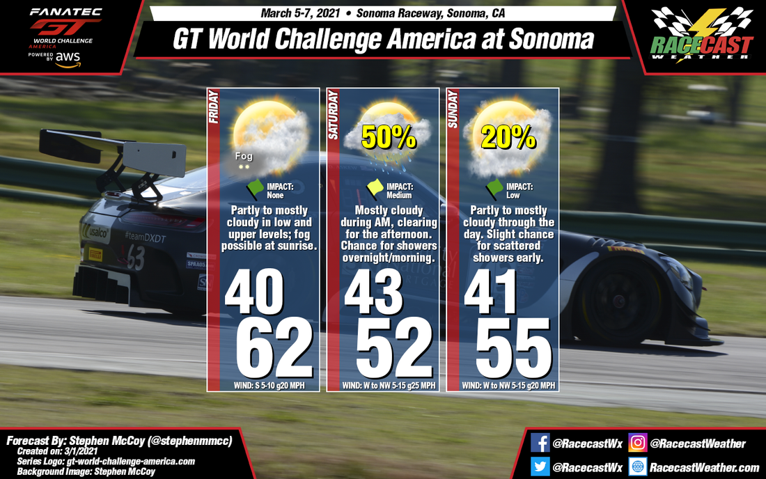
By: Stephen McCoy 
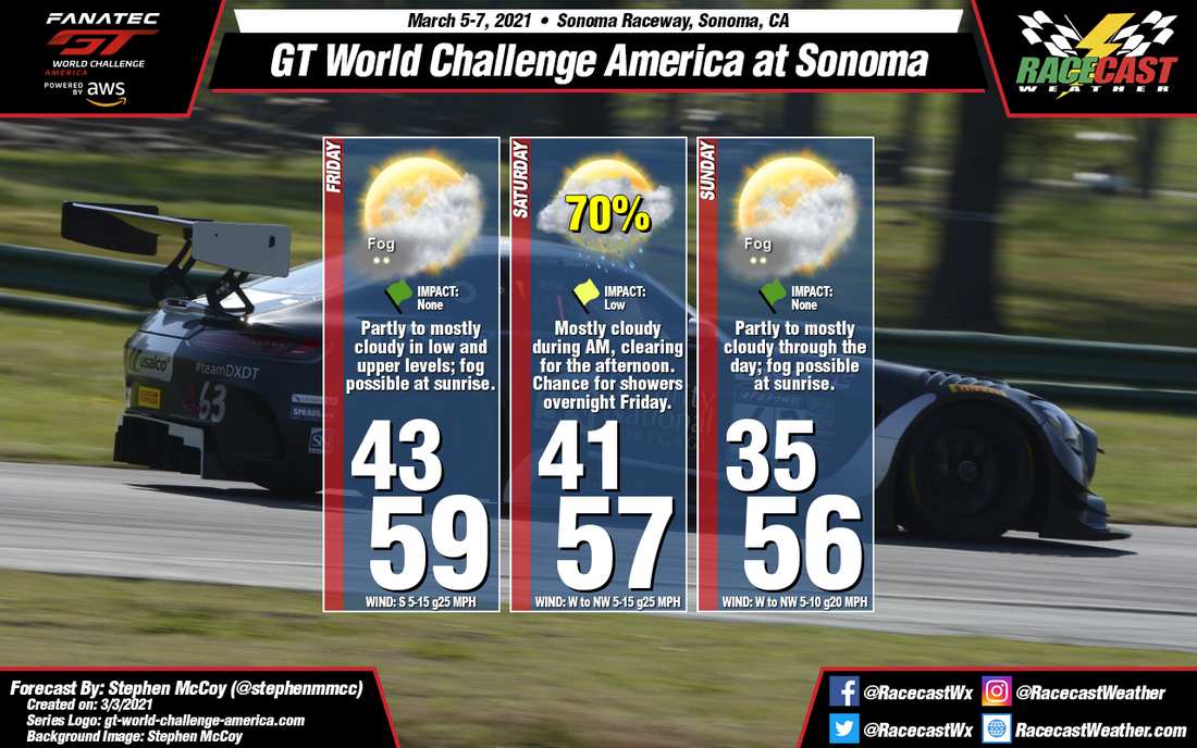
Little change to the conditions for this weekend's races at Sonoma Raceway. A cold front approaching the region from the West towards the end of the week will cause warmer temperatures to occur in the region as winds ahead of the front will bring in air from the South. Moisture from the Pacific will bring the possibility for fog Friday morning, but should clear by mid-day. The front is expected to move through the Bay area overnight Friday into Saturday morning, resulting in a likely chance for showers during the overnight period, but conditions during the day should be dry. Winds behind the front from the West/Northwest will cause temperatures to cool slightly for the remainder of the weekend.
By: Stephen McCoy After a quick warm-up for the early part of the week, cooler conditions will move in for the weekend with chances for precipitation on Saturday and Sunday.
Fog may be present to start of Friday morning due mostly clear nighttime conditions and surface/low level winds from the South bringing moisture off the Pacific. These winds will continue for most of the day as the result of a cold front approaching from the west. Warm air moving ahead of the front will give a high temperature for the day in the low 60's. Conditions for the day will be partly cloudy with cloud cover increasing into the evening and overnight. The cold front is expected to move through the Bay area early Saturday morning, resulting in a chance for showers mainly before noon.Winds will shift behind the front to the West/Northwest, bringing cooler air to the region, with a high anticipated in the low 50's. Wind speeds are expected between 5-15 MPH through the day, with some gusts possible upwards of 25 MPH. The cooler conditions from Saturday will linger into Sunday along with a slight chance for scattered showers during the morning. By Doug Schneider Quite a bit of rain has fallen today at COTA, with just over a half inch of rain recorded at the Austin airport a few miles northwest of the track as of 4 pm CDT. The good news is that the rest of the event should be rain-free, with comfortable temperatures and plenty of sunshine.
The upper level low pressure system that brought rain to the area today will be tracking to the east, pushing rain off the Texas coast on Friday. With dry air expected to build in through the day, clouds will be decreasing from mostly cloudy in the morning to mostly sunny in the afternoon. The weekend weather continues to look great, with sunny skies Saturday and Sunday, with a northeast wind providing comfortable temperatures and humidity levels. There is one thing to note that I don't think will impact the racing, but could be a factor for Sunday night and Monday - A tropical system is expected to develop off the Texas coast over the weekend, and may start to drift to the west late Sunday. Rain may begin to spread back into COTA on Sunday night, but well after the racing has been completed. By Doug Schneider The World Challenge event at COTA this weekend with start with a threat of rain as practice begins on Thursday, but conditions will improve through the event, with beautiful weather expected Saturday and Sunday.
A low pressure trough in the mid and upper levels of the atmosphere will be over Texas on Thursday, and with plenty of tropical moisture in the area, there will be numerous showers and thunderstorms near COTA. Some of the rain may be quite heavy if a storm passes directly over the track. With the chance of rain being at 60% and the potential for the rain to be heavy, I have rated the Impact as Moderate, meaning that there may be some interruptions or delays to some on-track sessions. The trough will be tracking slowly east on Friday, but it will still be close enough to COTA that I have to keep a small chance of rain in the forecast for Friday. I expect that most of the showers will occur on Friday morning, with clearing conditions through the afternoon. A large high pressure system will start to take hold across much of the central United States on Saturday, extending across Texas. It will remain firmly in control of the weather through the weekend, providing sunny skies both Saturday and Sunday, with comfortable temperatures and lower humidity. By Doug Schneider The main change to the forecast since Tuesday is a shift in the timing of the best chance of showers and thunderstorms on Saturday. Fortunately, this change is for the better, as the majority of rain is expected to pass through south-central Virginia on Friday night and early Saturday morning, with a low chance of impacts on the racing action.
Some pop-up afternoon showers and thunderstorms will be possible on Friday, mainly near the higher terrain to the west of Danville. They will be moving east, but the chance of one of them reaching VIR before the end of the day's sessions is unlikely. A passing trough and cold front are likely to bring showers and thunderstorms overnight and into early Saturday morning. There is a chance that some of the morning sessions could be impacted by these showers, possibly the GT qualifying from 8:30 to 9 am, and possibly the GT4 Sprint race at 9:25 am. Through the rest of the day, clouds will clear out and it will be mostly sunny, with high temperatures around 90 degrees. Drier air behind the departing trough will keep Sunday dry and sunny, with a high temperature around 90 again. By Doug Schneider The season opener for GT World Challenge at VIR may be affected by some showers and thunderstorms, particularly on Saturday, but the vast majority of the racing action should be completed in dry conditions.
A low pressure system is expected to be moving northeast across South Carolina and eastern North Carolina on Thursday. Even though it's just a couple days away, there are some big differences between the models in their placement of this low, and how much rain it brings to VIR. I'm going to be optimistic with my forecast, and only have a 30% chance of afternoon showers and thunderstorms. This is how most of the models are leaning, but the NAM shows much greater shower coverage. Hopefully it's an outlier. On Friday the low pressure system will be moving up the East Coast, and will no longer affect southern Virginia. With a lack of any significant high or low pressure systems in the area, I expect that Friday will be a typical summer day, with a few isolated showers or a thunderstorm possible in the afternoon, and a high around 90 degrees. Saturday appears to have the best chance of rain as an upper level trough and a surface cold front approach from the west. This system will provide lift and instability that will favor the development of showers and thunderstorms, mainly in the afternoon. There is a little uncertainty about the timing of the trough passage, and if it comes earlier there could be some morning showers as well. But the afternoon will be the more likely timing. Drier air aloft will build across the area behind this system, and which should result in a dry and mostly sunny day on Sunday. It will still be rather hot, with a high around 90. By: Stephen McCoy Conditions remain mostly the same for this weekend at Circuit of the Americas, besides the cooler temperatures on Saturday and a minor chance for precipitation Sunday evening after track activities have concluded.
For Friday, expect near-average temperatures as a surface high pressure system to the North causes winds from the North to Northeast through the day. Mostly saturated air in the upper levels will cause mostly cloudy skies, but the sun may still show through the clouds depending on how thick the cloud deck is. Similar conditions are expected for Saturday, though temperatures will be a few degrees cooler, most likely due to Easterly winds overnight. A southerly shift in winds Saturday into Sunday will bring warmer temperatures to the region along with a low chance for light showers during the late afternoon to evening. By: Stephen McCoy Much more pleasant conditions for the GT World Challenge America season opener than last year, with near-average temperatures and mixed amounts of cloud cover through the weekend.
Conditions for this weekend begin earlier this week as an upper level low pressure trough moves eastward over Northern Mexico and the US Southwest. A surface low pressure system will be present ahead of the trough with a cold/stationary front extending further East. The front is expected to bring rain with thunderstorms to the region on Tuesday into Wednesday morning. As the trough and low pressure move into the Southeast US, high pressure will begin to build in ahead of an upper level high pressure ridge, which will remain over the South-central US into next week. On Friday, the surface high will be centered to the North/Northeast, causing winds mostly from the Northeast through the day and temperatures near the daily average, though a bit cooler than earlier in the week. Cloud cover will begin increasing in the upper levels overnight Thursday into Friday as Southwesterly winds bring moisture in from the Pacific Ocean. For the remainder of the weekend, the surface high will continue moving eastward, resulting in winds slowly shifting to the East to Southeast on Saturday, then to the South to Southeast on Sunday. Some of the cloud cover will break up for Saturday as drier air moves in, however mostly cloudy to overcast conditions will be present on Sunday as mid level winds bring increased moisture to the region from the Gulf of Mexico while the upper level winds resume in carrying moisture from the Pacific. |
Social Feeds
Authors
Doug Schneider Partners
Categories
All
Archives
December 2023
|