
By Doug Schneider

(Updated Tuesday 10/4 for the latest Matthew forecast)
It's going to be an interesting weather week across southeast Florida as Hurricane Matthew will be tracking near the area. The good news is that Matthew is expected to be gone by the time the on-track activity starts for Trans Am at Homestead-Miami Speedway.
Here's the latest forecast track from the National Hurricane Center for Hurricane Matthew (as of Tuesday morning, 10/4), which is now a strong Category 4 hurricane with winds around 145 mph:
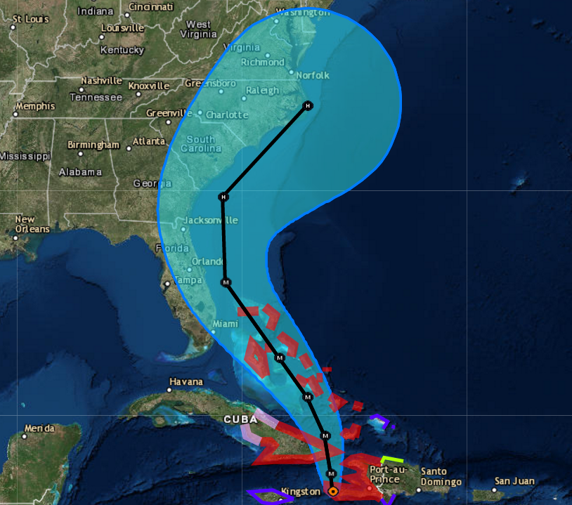
The center of Matthew is expected to be due east of Miami on Thursday, and it will be tracking parallel to the Florida coast. As teams load into the track on Thursday, it will be very windy, with north winds blowing at 20 to 30 mph, and gusts over 40 mph are possible at times, mainly Thursday afternoon and evening. Showers are likely on Thursday as well, possibly heavy at times, with a slight chance of thunderstorms.
If the track of Matthew ends up being on the western side of that blue forecast cone, then winds will be higher and rain will be heavier and more frequent. Currently, there is no concern of Matthew making a direct hit on the Miami area, and there is good model agreement that it will remain off the Florida coast.
A few showers will be possible into Friday as Matthew pulls away, mainly in the morning. Winds will be lighter, from the west at 15 to 25 mph, with gusts to around 30 mph. The rest of the weekend will be rain-free, but the high humidity levels will make it feel rather muggy - typical for south Florida.
Unless there is a significant change to the forecast, I plan have another update posted on Thursday.


