I'll be away with family this weekend, and I most likely won't be able to post another forecast update, but I don't think it will be needed anyway. I don't expect this forecast to change much at all.
By Doug Schneider 
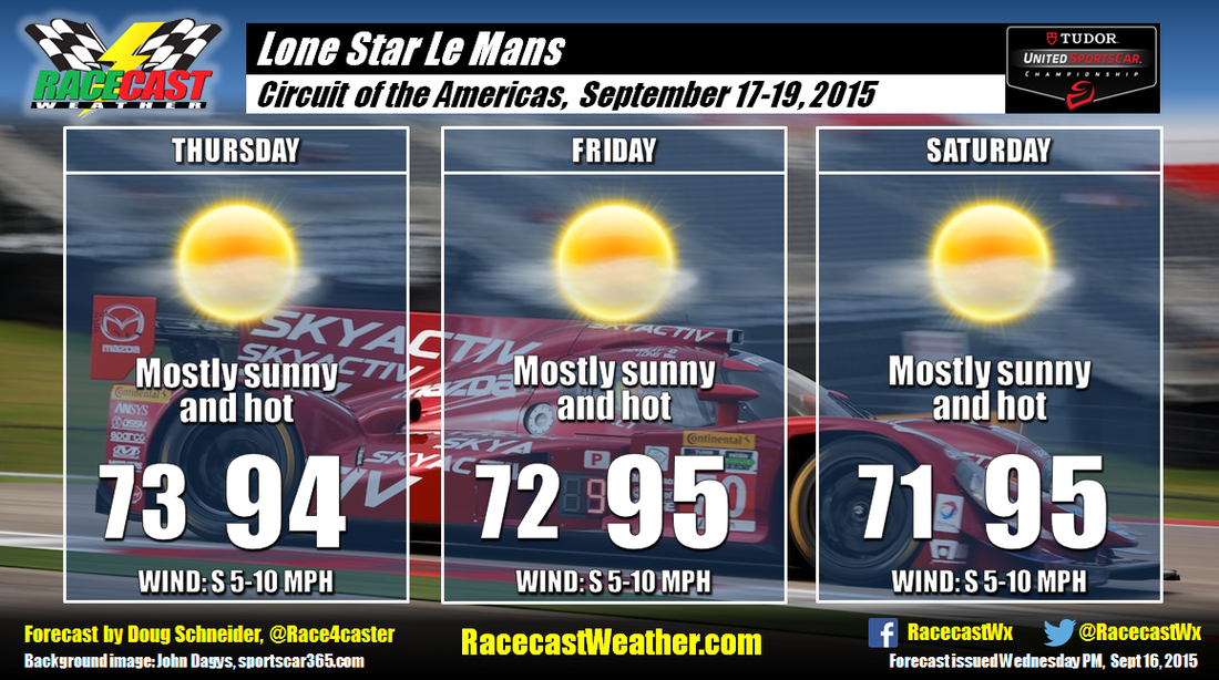
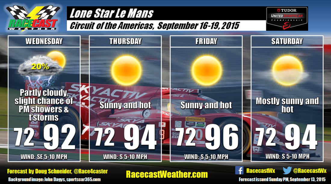
Currently there are some isolated showers around the Austin area, but this will be the only threat of rain throughout the Lone Star Le Mans weekend. A strong ridge of high pressure will be building over Texas, which will provide dry and stable conditions. The main weather concern at the track will be the heat. High temperatures will reach into the mid 90s each day. With dewpoint temperatures around 70, heat index values near 100 can be expected in the middle of each afternoon. If you're at the track, be sure to stay hydrated and use plenty of sunscreen.
I'll be away with family this weekend, and I most likely won't be able to post another forecast update, but I don't think it will be needed anyway. I don't expect this forecast to change much at all. By Doug Schneider It's a big racing weekend at Circuit of the Americas as the WEC comes to the States, joining TUSC and CTSC. The first look at the weather for the event looks dry for the most part, but it will be quite hot.
The weather pattern by midweek will feature a large area of surface high pressure over the eastern half of the United States. The clockwise flow around the high will result in a southeast wind across Texas on Wednesday, which will transport some moisture into the Austin area. This could result in a few showers and thunderstorms Wednesday afternoon. It is only a 20% chance, so it should not have too much impact on the practice sessions. By Thursday, the flow will shift to a more southerly direction, and high pressure in the mid and upper levels will be building over Texas, and remain overhead through Saturday. This will provide a more stable atmosphere and less moisture, so showers and thunderstorms do not appear to be a threat for the rest of the weekend. However, it will be hot, with high temperatures Thursday through Saturday in the mid 90s. For those who will be at the track, be sure to drink plenty of water and use plenty of sunscreen. By Doug Schneider The forecast continues to look great for the Oak Tree Grand Prix this weekend. A cold front is located over the Tennessee Valley this afternoon, and there will be showers around the track through the evening as the front moves through. It will exit the area around midnight, and high pressure will be building in through the night. It will supply drier air to southern Virginia through the weekend, and afternoon humidity levels will feel quite comfortable for late August. Mornings will even be a little on the cool side with the dry air mass, with lows in the lower 60s. There will likely be some amount of cloud cover Saturday and Sunday, mainly some scattered to broken high clouds. You'll want to have some kind of sun protection if you're at the track. High temperatures will be warm but no excessively hot, in the mid to upper 80s. Looks like I picked the right year for my first visit to VIR.
By Doug Schneider My confidence in the forecast is much higher today as the models are in better agreement, and are showing better consistency from run to run. And fortunately, the outlook is trending in a drier direction.
The models show the weather pattern evolving a little more quickly than when I did the forecast yesterday morning. A cold front will be approaching the Appalachians on Thursday, and there will be plenty of moisture ahead of the front for showers and thunderstorms on Thursday. By Friday, the front will have moved through and fizzle out, and high pressure begins to build into the area. Drier air aloft will move in from the northwest, and push the shower and thunderstorms activity toward the coast and across the Carolinas, away from VIR. So it looks like Friday will be a dry day, despite some morning clouds. Saturday and Sunday will feature a surface high pressure ridge extending northeast to southwest along the Virginia foothills and Piedmont, with a mid to upper level ridge over Florida. This pattern looks favorable for dry conditions each day, with a good amount of sunshine. Temperatures and humidity won't be excessively high, with temperatures reaching into the mid to upper 80s and dewpoint temperatures in the 60s. By Doug Schneider Here's my first shot at the forecast for the Oak Tree Grand Prix at VIRginia International Raceway. I'll say up front that there is some uncertainty to this forecast, so I expect that there will be some changes through the week. But as it stands today, this is my best estimate of what to expect.
The general weather pattern toward the end of the week will be a low pressure system tracking northeast across the Great Lakes region, with high pressure over the western Atlantic Ocean. This pattern will supply a southwest flow of moisture across the southeast United States Thursday and Friday, and bring a chance of afternoon showers and thunderstorms. I have the most confidence in this part of the forecast. For Saturday and Sunday, my confidence decreases as the models show some different scenarios. Right now, I favor a scenario in which the high pressure over the Atlantic will build westward, and this will suppress the chance of showers and thunderstorms over the weekend. If the ridge does not build west, then the flow of moisture from the Gulf of Mexico will continue, and there will be a chance of afternoon showers and thunderstorms Saturday and Sunday. I'll be at the race Saturday and Sunday, and it would be great to meet you. I'll probably be wearing an NC State shirt or hat both days. By Doug Schneider Overcast clouds and fog will start the day at Road America, but will gradually start to decrease through the morning. The low pressure system that was expected to bring rain to Road America is passing well to the south this morning, and will move across northern Illinois today. This should result in a dry race. However, I can't rule out some isolated showers in the late afternoon around the area, so I mentioned a 20% chance of one hitting the track. If there are any, they will be light and not last long.
By Doug Schneider After getting around a half inch of rain yesterday, it should be a dry day at Road America. There will be plenty of cloud cover, especially in the morning, but no rain is expected.
Sunday continues to be a difficult day to forecast, with the models constantly in flux. But the good news is that the system that is expected to bring a chance of rain now appears likely to pass further south than it appeared yesterday. The bulk of the rain will pass well south of Road America, so I've lowered the chance of rain to 30%. There could still be some scattered showers and thunderstorms in the area, mainly in the afternoon hours. If there is a shower on Sunday, it probably won't produce very heavy rain or last for very long. By Doug Schneider As you can see from the radar image above, an area of rain is moving east toward Road America this morning. The bulk of this rain will be moving through from the late morning through early afternoon hours. Some scattered showers may linger into the late afternoon and early evening, but the chance of rain should end around sunset.
Saturday still looks dry, but with quite a bit of cloud cover. The day will likely start off with overcast clouds, with some breaks in the clouds allowing for a little sunshine to peek through in the afternoon. Highs will be in the upper 70s. My confidence is increasing that there will be rain on Sunday, as the models are coming into better agreement. The question is the timing. At this point, there could be a chance of showers and thunderstorms at any time of the day. The timing should become a little more clear tomorrow. I don't think it will be a steady soaking rain - more like numerous on/off showers with a few thunderstorms possible at times. Rain amounts on Sunday could range from a quarter inch to half inch. Unfortunately, we have having some technical problems with getting our radar posted to the website, so our usual radar link won't be available this weekend. I recommend this radar link from the National Weather Service. |
Social Feeds
Authors
Doug Schneider Partners
Categories
All
Archives
December 2023
|